Instrument Proficiency Check
Pilot Qualifications, Privileges, and Currency
When an Instrument Rating Is Required
When do you need an instrument rating?
To act as PIC for a flight:
- Under IFR
- Weather that does not meet VFR minimums
- Anytime in Class A airspace
- Special VFR at night
- Carrying passengers for hire at night or on a flight more than 50 NM
Sources
What type of aircraft will the instrument rating permit you to fly as PIC in IMC?
Any airplane for which you are rated and otherwise qualified to act as PIC.
Sources
Instrument Rating Experience Requirements
What flight experience do you need for an instrument rating?
- 50 hr of cross-country PIC time, including 10 hr in airplanes
- 40 hr of actual or simulated instrument time, including 15 hr with a CFII
- Up to 30 hr of the required instrument time may be completed in a full flight simulator or flight training device if completed under Part 142; otherwise, the maximum is 20 hr.
- 3 hr of instrument training in an airplane within 2 calendar months before the practical test
- 250 NM cross-country flight with a CFII under an IFR flight plan along airways or an ATC-directed route, with 3 different types of approaches
Sources
Required Pilot Documents
What documents do you personally need to carry with you to act as PIC?
- Pilot certificate
- A current FAA medical certificate of the class your flight requires
- Government-issued photo ID
All three must be in your physical possession or readily accessible in the aircraft.
Showing them on request. You must present your pilot and medical certificates, or your BasicMed documents, together with your photo ID, when any of these asks to inspect them, § 61.3(l):
- The FAA
- An authorized NTSB representative
- Any federal, state or local law enforcement officer
- An authorized TSA representative
Your logbook falls under a separate rule, § 61.51(i): present it on reasonable request by the FAA, the NTSB, or law enforcement. The TSA is not on that list.
Under BasicMed there is no medical certificate to carry. You hold a U.S. driver's license, and the completed examination checklist and course completion certificate must be available in your logbook, § 61.113(i)(3).
Exercising commercial privileges in an aircraft other than a balloon or glider takes at least a second class medical, § 61.23(a)(2)(ii). BasicMed covers only student, recreational and private pilot privileges, and a flight instructor acting as PIC, § 61.23(c).
Sources
- 14 CFR § 61.3(a) - Required pilot certificate
- 14 CFR § 61.3(c) - Medical certificate requirement
- 14 CFR § 61.3(l) - Inspection of certificate
- 14 CFR § 61.51(i) - Presentation of required documents
- 14 CFR § 61.23 - Medical certificates: requirement and duration
- 14 CFR § 61.113 - Private pilot privileges and limitations: Pilot in command
Instrument Currency
If you had a multi-engine rating in addition to a single-engine rating and got instrument current in the multi-engine, are you instrument current in the single-engine?
Yes, currency applies to the category, not the class, of aircraft.
What experience do you need to legally act as PIC on an IFR flight plan?
- Within the preceding 6 calendar months: 6 IAPs, holding procedures/tasks, and intercepting/tracking courses
- Current flight review
- Current FAA medical
- Landing currency if carrying passengers
Sources
You flew 6 IAPs and intercepted courses in a simulator today, but last flew a hold 7 months ago. What do you need to do to be current?
Complete one holding procedure/task, either in an approved simulator or in an airplane with a safety pilot, CFI, or DPE.
Sources
Supplements
You last flew a hold 13 months ago. What do you need to do to be current?
Perform an IPC with a CFII or DPE.
Sources
Supplements
Your flight was in solid IMC. Just before intercepting the glideslope at the FAF, you transitioned to VFR. Can you log that IAP for currency?
- No. To log an IAP for currency, you must be in IMC until the final approach segment.
- When using a view-limiting device, you must descend to the DA/MDA to count the IAP toward currency.
Sources
Safety Pilot Rules and Logging
How do you log time with a safety pilot?
- The pilot flying under the hood may log PIC as sole manipulator if rated for the airplane.
- The safety pilot may log PIC only if acting as PIC by agreement; otherwise, they may log SIC while serving as a required crewmember. Include the safety pilot's full name in the remarks.
Sources
What qualifications does a safety pilot need?
They must be rated in the category and class of aircraft being used and have a current FAA medical because they are a required crewmember.
Sources
Does a safety pilot need an instrument rating if you are logging time under the hood?
Does a safety pilot need a current flight review?
No, unless they are acting as PIC.
Sources
If you are flying under the hood in a high-performance airplane for which you have an endorsement, must your safety pilot also have a high-performance endorsement?
If prior to the flight it is agreed that the safety pilot will be acting as PIC, then yes, they need the endorsement. If they are not acting as PIC, though, they do not, and can log SIC time because they are a required crewmember.
Sources
Supplements
IPC Requirements
Where can we find the requirements of an IPC?
Instrument Airplane ACS
Sources
Personal Minimums and Risk Management
What are your personal minimums?
- Ceiling and visibility requirements should reflect your recent instrument experience.
- Avoid flying to published minimums unless very current and experienced in actual IMC.
Sources
- FAA AC 61-98E - Currency Requirements and Guidance for the Flight Review and Instrument Proficiency Check
- FAA Pilot's Handbook of Aeronautical Knowledge, Chapter 2 - Aeronautical Decision-Making
- 14 CFR § 61.57(c) - Instrument experience required for IFR PIC
- 14 CFR § 61.57(d) - Instrument proficiency check
Supplements
Aircraft Airworthiness and IFR Equipment
Required Equipment for IFR Flight
What equipment must be installed and operative to operate IFR?
Day VFR:
- Airspeed indicator
- Tachometer (for each engine)
- Oil pressure gauge (for each engine)
- Manifold pressure gauge (for each altitude engine)
- Altimeter
- Temperature gauge (for each liquid-cooled engine)
- Oil temperature gauge (for each air-cooled engine)
- Fuel gauge
- Landing gear position indicator (if applicable)
- Anticollision lights (beacon or strobes, for aircraft certificated after March 11, 1996)
- Magnetic direction indicator (either magnetic compass or magnetometer)
- Emergency location transmitter
- Seat belts
Night VFR (in addition to day VFR equipment)
- Fuses or circuit breakers (if fuses, one spare set or three of each kind)
- Landing light (if for hire)
- Anticollision lights (beacon or strobes)
- Position lights (nav lights)
- Source of power (e.g., alternator or generator)
IFR (in addition to VFR equipment):
- Generator or alternator (source of electricity)
- Radio (two-way communication and navigation equipment suitable for the route to be flown)
- Altimeter (pressure-sensitive and adjustable)
- Ball (inclinometer)
- Clock (with hours, minutes, and seconds)
- Attitude indicator
- Rate of turn indicator
- Directional gyro (or HSI)
Sources
Inoperative Equipment Scenarios
Your VOR receiver is inoperative, but you filed an IFR route that uses only GPS waypoints. Can you fly?
If no portion of your route requires VORs for navigation or GPS can be substituted for VORs, then yes.
Sources
Your pitot heat is not working. Can you fly?
Since it is not required per 14 CFR § 91.205, as long as it's not required on your aircraft's equipment list - yes. However, it may be unsafe if flying in visible moisture and freezing temperatures. Per 14 CFR § 91.213, you must placard the pitot heat switch and deactivate it (eg pulling a circuit breaker and zip tying it to prevent reactivation prior to service).
Sources
Required IFR Inspections
What inspections are required specifically for instrument flight, and how frequently must they be done?
- VOR - Every 30 days
- Altimeter - Every 24 calendar months
- Transponder - Every 24 calendar months
Sources
VOR Checks
What are the different types of VOR checks?
Ground:
- VOR Test Facility (VOT): +/- 4°
- Set the course to 360°, and it should be centered with a FROM indication.
- Set the course to 180°, and it should be centered with a TO indication.
- Certified ground checkpoint: +/- 4°
- Found in Chart Supplement
- Follow instructions on local signage.
Air:
- Airborne checkpoint: +/- 6°
- Select a VOR radial that lies along the centerline of a VOR airway.
- Select a prominent ground point roughly 20 NM from the VOR that is along that radial.
- Note the indicated VOR bearing as compared to the charted course.
- Dual check: +/- 4°
- Tune both nav radios to same station and center both.
- VOR Test Facility (VOT): +/- 4°
What do you need to log with a VOR check?
Date, error, location of check, and signature
It's been 31 days since you've done a VOR check. Can you fly a route that is GPS-only, ending with an ILS?
Yes. VOR checks are only required for VORs, not GPS or ILS.
GPS Database / AFM / Equipment Codes
Where can you find what equipment codes apply to your aircraft?
Your Aircraft Flight Manual (AFM) and avionics supplements will list approved equipment and navigation capabilities.
Sources
N3096B-Specific Equipment and Limitations
What is the benefit to AHRS over a vacuum system?
Fewer mechanical parts that can break, and less prone to gyro tumbling.
Sources
In N3096B, can you switch your PFD and your MFD?
No, you must rely on standby instruments.
Sources
In N3096B, can you use GPS on your standby OBS?
No, you must use VLOC.
Sources
ATC asks you to continue holding after you performed a hold in lieu of a procedure turn. How do you do that with the IFD440?
Press the "Continue Hold" button before crossing the holding fix inbound.
Sources
Weather Products and Weather Decision-Making
Weather Briefing Strategy
What might you want to know about the weather when your flight will take you into IMC?
- Cloud tops and bottoms
- Freezing level
- Nearest VMC in the case of electrical failure
- Potential for embedded thunderstorms
Sources
What are the types of preflight weather briefings, and what's in a standard one?
- Standard - The full picture, for when you haven't looked at anything yet. It covers adverse conditions, VFR flight not recommended when applicable, the synopsis, current conditions, enroute and destination forecasts, winds aloft, NOTAMs, and ATC delays.
- Abbreviated - An update to a briefing or data you already have. Tell the briefer what you've already seen and when you saw it.
- Outlook - For a departure 6 or more hours away. Forecast information only.
All three are also available in flight via Flight Service. You can also get a compliant briefing by self-briefing with qualified sources (e.g., ForeFlight) because § 91.103 is about having the information, not about how you got it.
Sources
Weather Condition Categories
What defines IFR conditions? LIFR?
IFR conditions are those less than VFR, specifically ceilings less than 1,000 ft and/or visibility less than 3 SM. LIFR, or low instrument flight rules, conditions are technically still IFR, but tell you that ceilings and/or visibility are especially low, specifically ceilings less than 500 ft and/or visibility less than 1 SM. Only highly and recently experienced instrument rated pilots should attempt flying in these conditions.
What is MVFR?
Marginal VFR. It's weather that's approaching IFR, but is still legally VFR - 1,000-3,000 ft ceilings and/or 3-5 SM visibility. If you are instrument rated, it's a good idea to file IFR in these conditions.
TAFs
What is a TAF, what area does it cover, and how often is one issued?
A concise statement of the expected conditions significant to aviation, for a specified period, within 5 SM of the center of the airport's runway complex. It is a terminal forecast, not an area forecast.
- Issued four times a day, every 6 hr, at 0000, 0600, 1200 and 1800Z, and amended as needed. Some locations routinely issue an amendment 3 hr after the initial.
- Most run 24 hr; some major airports run 30 hr.
- It uses the same weather codes as a METAR, so if you can read one you can read the other.
- Temperature is not in the NWS TAF. If you need a forecast temperature, that comes from the LAMP/MOS product.
Sources
AIRMETs, SIGMETs, and Convective SIGMETs
What are AIRMETs, what do they cover, and how often are they issued?
Advisories for en route weather that may be hazardous, especially to light aircraft. Three categories, and the letters are what you will be asked for:
Covers Sierra IFR conditions, ceilings below 1,000 ft and/or visibility below 3 SM, and widespread mountain obscuration Tango Moderate turbulence, sustained surface winds greater than 30 kt, and non-convective low-level wind shear potential below 2,000 ft AGL Zulu Moderate icing, and freezing level heights Timing comes in two forms. Over the CONUS they are displayed graphically, sometimes called G-AIRMETs, valid at discrete times no more than 3 hr apart out to 12 hr. The text bulletin behind them is issued every 6 hr (0245, 0845, 1445 and 2045Z) and is valid 6 hr. Unscheduled AIRMETs are issued when conditions occur that were not forecast.
The difference from a SIGMET is severity and audience: moderate conditions hazardous to light aircraft, against severe conditions hazardous to all aircraft.
Sources
Supplements
What are SIGMETs, what weather are they issued for, and how often?
Advisories for non-convective en route weather hazardous to all aircraft, not just light ones. Unscheduled: issued any time the criteria are occurring or expected within a 4 hr period.
Inside the CONUS, the criteria are:
- Severe or greater turbulence
- Severe icing
- Widespread dust storm
- Widespread sandstorm
- Volcanic ash
A CONUS SIGMET is valid up to 4 hr, and is reissued at least every 4 hr while the condition continues.
Outside the CONUS the list also includes thunderstorms (obscured, embedded, widespread, squall line, isolated severe) and tropical cyclones, and volcanic ash and tropical cyclone SIGMETs can be valid up to 6 hr.
Convective weather inside the CONUS gets its own product, the Convective SIGMET.
Sources
Supplements
What are Convective SIGMETs, what weather are they issued for, and how often?
The thunderstorm advisory, issued for the CONUS instead of a SIGMET. Issued every hour at 55 minutes past the hour, valid 2 hr.
What triggers one:
- Tornadoes
- Severe hail
- Severe surface winds
- Squall lines
- Widespread thunderstorm activity
- Embedded or severe thunderstorms
Any Convective SIGMET implies severe or greater turbulence, severe icing and low-level wind shear, so those are never listed separately.
The polygon is a snapshot at the issuance time. During the valid period the area moves along the vector given in the text, so a fast-moving line will not be where the graphic drew it.
Sources
Supplements
Surface Analysis Charts
How frequently are surface analysis charts issued?
Every 3 hr, but it takes around 90 minutes to create them, meaning they're always a little out of date.
What is the blue "H" over Arizona, and what kind of conditions are associated with it?
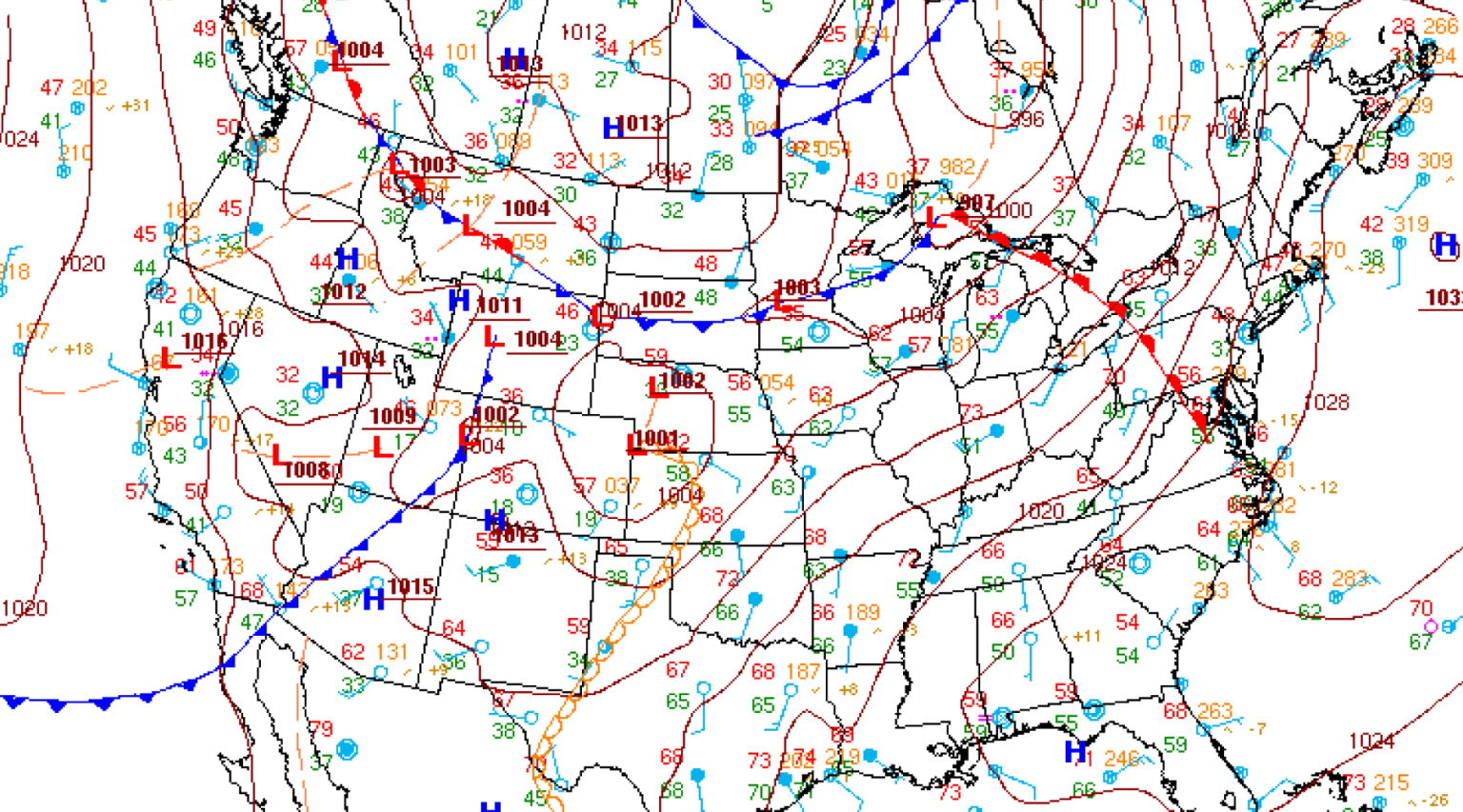
- A high-pressure system, with air generally sinking, moving outward, and rotating clockwise
- It results in stable conditions such as smooth air and few clouds.
What is the red "L" over Utah, and what kind of conditions are associated with it?
- A low-pressure system, with air generally rising, moving inward, and rotating counterclockwise
- It results in unstable conditions such as rain, wind, icing, and even thunderstorms.
What is the red line stretching from western Michigan to Virginia, and what kind of conditions are associated with it?
- A warm front, where a warm air mass advances over a cooler air mass.
- Weather changes are slow, and may include light rain, drizzle, and a temperature rise.
What is the blue line stretching from the Pacific up to South Dakota, and what kind of conditions are associated with it?
- A cold front, where a cold air mass advances under and lifts a warmer air mass.
- Weather changes are abrupt and typically more severe, including thunderstorms, heavy rainfall, and a temperature drop.
What is the red and blue line over Montana, and what kind of conditions are associated with it?
- A stationary front, where two air masses meet but neither advances significantly.
- Weather tends to persist and can produce low IFR conditions, including rain.
Tell me about the weather going through western/northern Texas.
A dry line is moving through, which can trigger intense, fast-developing supercell thunderstorms, hail, and tornadoes due to the sudden uplifting of the nearby moist air.
What are all the lines going across Illinois, and what are the numbers you find along them?
- Isobars, which indicate lines of equal pressure.
- The numbers are the pressure (in millibars).
Refer to the surface analysis chart from the source guide.
If there are many isobars closely spaced together, what kind of conditions can you expect?
Refer to the surface analysis chart from the source guide.
How do winds typically move in relation to isobars?
- Above the friction layer the wind blows parallel to the isobars. The pressure gradient force and the Coriolis force are in balance, which is the geostrophic wind.
- Friction near the surface breaks that balance. It slows the air, and slower air feels less Coriolis force, while the pressure gradient force is unaffected.
- The now-stronger pressure gradient force turns the surface wind at an angle across the isobars toward lower pressure: outward and clockwise around a high, inward and counterclockwise around a low.
- Wind at 2,000 ft AGL runs 20° to 40° to the right of the surface wind and is faster. The shift is greatest over rough terrain and least over open water.
- Spacing shows strength. Closely spaced isobars mean a steep gradient and strong winds; isobars far apart mean light winds.
Sources
What is the dashed brown line going over the Gulf of California, and what kind of conditions can you expect?
- A trough, which is an elongated area of relatively low pressure.
- It brings gusty winds, clouds, and precipitation.
What is a ridge, and what kind of conditions are associated with it?
- An elongated area of relatively high pressure
- It brings clear skies and light winds.
What is an occluded front, and what kind of conditions are associated with it?
- Looks similar to a stationary front, but is entirely purple
- It happens when a cold front, which typically moves faster, catches up to a warm front moving in the same direction.
- When the cold front is colder than the air in front of the warm front ("cold front occlusion"), it lifts the warm air up and generates heavy rainfall.
- When the cold front is warmer than the air in front of the warm front ("warm front occlusion"), it slides in between the warm and colder air and generates gradual weather changes, including prolonged periods of rain.
Prognostic Charts and GFA
What are prognostic charts, and what do they show you?
Short-Range Surface Prog Charts are the forecast counterpart to a surface analysis chart: same kind of picture, but of conditions expected rather than observed.
- Produced by the Weather Prediction Center for the CONUS and coastal waters, covering a multiday period.
- They plot surface pressure systems, fronts and precipitation, combining WPC forecasts of fronts, isobars and highs and lows with the National Digital Forecast Database.
- The period is divided into selected valid times, and each chart is a snapshot of what is expected at its own valid time, not a summary of the span.
- Precipitation is shown by type and probability: rain green, snow blue, mixed purple, freezing rain red, each in a light shade for chance (25% to under 55%) and a dark shade for likely (55% or more). Thunderstorms are red diagonal hatching.
Sources
PIREPs
What is a PIREP?
A pilot report of actual weather conditions
Sources
What are the different types of PIREPs?
- UA (routine) and UUA (urgent)
- UA includes routine reports such as cloud tops, bases, and light conditions.
- UUA includes urgent reports such as severe turbulence, severe icing, and low-level wind shear.
Sources
Where can you find PIREPs?
Aviation Weather Center and weather briefing products
Sources
How do you file a PIREP?
Transmit the conditions to ATC, e.g., "Chicago Approach, Archer 12345. Cloud bases were at 2,000 ft MSL and tops were at 4,000 ft MSL."
Sources
Enroute Weather Updates
How can we get updated weather enroute?
ADS-B if equipped, Flight Service, ATC (workload permitting), and ATIS/ASOS/AWOS
What's the difference between ATIS, ASOS, and AWOS?
- Automated Terminal Information Service (ATIS) - Local weather data combined with non-weather operational details
- Automated Surface Observing System (ASOS) - Continuous, automated weather reporting with type/intensity of precipitation and fog/haze
- Automated Weather Observing System (AWOS) - Continuous, automated weather that reports basic meteorological data.
Adverse Conditions: Icing and Thunderstorms
There's an overcast layer 2,000-5,000 ft MSL. Your aircraft is non-FIKI. The MEA for your planned route is 4,000 ft, but the freezing level is 3,000 ft. There is no AIRMET Zulu. How do you proceed with planning your flight?
- Visible moisture plus below-freezing temperatures means there is an icing risk - do not fly this route.
- Could fly VFR under the clouds (or special VFR)
- If you desire to fly IFR, find a route/altitude that avoids the clouds, or wait for an improvement in the weather.
Sources
What are the different types of structural ice, how do they form, and what dangers does each present?
Type Description Formation Dangers Rime Rough, brittle chunks of ice that form on the leading edges Caused by super-cooled droplets hitting the aircraft and freezing instantly Severely disrupts airflow over airfoils Clear Smooth ice that spreads beyond the leading edges Caused by droplets moving backwards while freezing Much more difficult to remove because it goes beyond deicing boots/wing heat Mixed Mixture of rime and clear ice Caused by both super-cooled droplets and large droplets hitting the aircraft The most dangerous as you get all the dangers of rime + clear Frost White, sand-papery textured ice on aircraft surfaces Caused by moist air contacting surfaces below freezing Reduces lift by up to 30% and increases drag by up to 40% Supplements
What's the difference between deice and anti-ice equipment, and what does "known ice" approval mean?
- Anti-ice systems prevent ice forming and go on before you enter icing - heated pitot tube, heated stall warning vane, heated or alcohol-sprayed windshield, a propeller alcohol slinger ring, carburetor heat, engine inlet heat.
- Deice systems remove ice after a measurable amount has built up - most commonly pneumatic boots on the wing and tail leading edges, and electrically heated propeller boots that cycle through the blades to shed it.
- Sometimes the label follows the operation, not the hardware: cycled electrothermal propeller boots shed accumulated ice (de-ice) while continuous heating prevents it (anti-ice), and carburetor heat both prevents carb ice and clears it once formed. Read the placard.
- Alternate air is not ice protection. It's an alternate induction path for a blocked inlet or filter, and on many injected engines it opens automatically.
- Almost every airplane has some of this equipment, and a piece or two does not make an airplane approved for icing. Note also that § 91.205(d) does not itself require pitot heat for IFR - that comes from the AFM and the conditions you're operating in.
Known ice / FIKI approval
- FIKI means the airplane was certified with a complete, tested ice protection package and the AFM authorizes flight into known icing. It is an airplane-level certification, not a collection of parts - plenty of airplanes carry boots or a heated windshield without it.
- In a non-FIKI airplane, icing is an emergency in the making and the only plan is to leave: change altitude, reverse course, or land.
- Even with FIKI, the approval is a tool for leaving icing safely, not a license to loiter. No airplane is approved for severe icing, and ice raises stall speed while killing climb performance - your margins shrink exactly when you need them.
Sources
You're in IMC and notice you're unexpectedly accumulating ice. What do you do?
- Pitot heat on, defroster on, notify ATC, and request an immediate turn, climb, descent, or vector to exit icing conditions.
- Monitor for signs of carb ice and apply carb heat as necessary.
Supplements
How will you adjust your landing if you still have accumulated ice along the leading edge of your wings?
- Land at the nearest airport.
- Stall speed may be much higher, so use an appropriate higher approach speed.
- Consider a no-flap landing if recommended by the AFM/POH or checklist.
Supplements
What does a thunderstorm need to form, what are its stages, and what hazards does it present?
Three ingredients
- Sufficient moisture
- An unstable lapse rate
- A lifting action (a front, terrain, surface heating, or convergence)
Three stages
Stage What's happening Cumulus Updrafts build the cell, with no precipitation reaching the surface yet Mature Precipitation begins falling, so updrafts and downdrafts coexist. Every hazard is at its worst here Dissipating Downdrafts dominate and the cell rains itself out Hazards
Severe turbulence, wind shear and microbursts, hail (which can be thrown miles outside the cloud), severe icing, lightning, heavy rain, tornadoes, and a complete loss of visibility.
What it means for us
Never fly under a cell, since that's where the shear and hail live. Avoid anything severe or with an intense echo by at least 20 NM. Circumnavigate areas of heavy coverage rather than picking through them. And remember that an embedded cell in IMC gives you no visual warning at all.
Sources
Supplements
Convective activity popped up unexpectedly on your flight, and you're in IMC. You notice a gap between cells on your ADS-B/NEXRAD that you think would allow you to proceed. Do you?
No. Datalink/NEXRAD can be delayed, and the gap could already have closed.
Sources
Supplements
IFR Flight Planning
Required Preflight Information
What information do you need to have prior to any flight?
- NOTAMs
- Weather reports and forecasts
- Known ATC delays
- Runway lengths
- Alternatives available
- Fuel requirements
- Takeoff and landing distances
IFR Flight Plans
Can you fly IFR while not on a flight plan?
Yes. An IFR flight plan and ATC clearance are required for IFR in controlled airspace. If the flight is entirely in Class G, you do not legally need one, but you still should plan carefully.
Fuel Planning
What are IFR fuel requirements?
Enough fuel to fly to the first airport of intended landing, then to the alternate (if one is required), then for 45 minutes at normal cruising speed
If you didn't file an alternate, do you still need the 45-minute reserve?
Airspace and ADS-B Requirements
Do you need ADS-B out on an IFR flight when you only fly through Class E and G airspace?
Possibly. Required for:
- Class E at or above 10,000 ft MSL, excluding at or below 2,500 ft AGL
- Above the ceiling and within the lateral boundaries of Class B or Class C airspace up to 10,000 ft MSL
- Class E airspace over the Gulf of Mexico at and above 3,000 ft MSL within 12 NM of the U.S. coastline
- Mode C veil
Where is ADS-B Out required?
Required by § 91.225 in:
- Class A, Class B, and Class C
- Within 30 NM of a Class B primary airport, surface to 10,000 ft MSL, the Mode C veil
- Above the ceiling and within the lateral boundaries of Class B or Class C, up to 10,000 ft MSL
- Class E at and above 10,000 ft MSL, excluding airspace at and below 2,500 ft AGL
- Class E over the Gulf of Mexico at and above 3,000 ft MSL within 12 NM of the coast
Class A requires 1090ES. Below 18,000 ft MSL, either 1090ES or 978 UAT satisfies the rule.
ADS-B Out is what the regulation requires. ADS-B In, which puts traffic and weather in the cockpit, is never required.
How do you identify airports' airspace types on an enroute chart?
- Class B - Solid blue line around airspace
- Class C - In airport information, e.g., [C], plus a dashed blue line around it
- Class D - In airport information, e.g., [D]
- Class E/G - Not available on the enroute chart
Sources
Takeoff Minimums and Climb Rates
What is the standard IFR climb rate?
You must cross the departure end of the runway (DER) at a minimum altitude of 35 ft AGL and continue climbing to 400 ft AGL before making a turn. You must climb at 200 ft/NM.
Sources
How do you calculate 230 ft/NM to an actual climb rate for your VSI given a groundspeed of 90 kt?
- Climb rate (fpm) = Gradient (ft/NM) x (Groundspeed (kt) / 60)
- 345 fpm = 230 x 90 / 60
Sources
IFR Alternates
You're renting a non-WAAS GPS equipped aircraft and planning a flight to an airport that is forecasting 900 ft ceilings and 3 SM visibility 30 minutes after your ETA. How does that impact your flight planning?
- You must file an alternate.
- That alternate must have something other than a GPS approach.
Sources
Supplements
What are the requirements for filing an alternate?
- 1-2-3 rule: from 1 hr before to 1 hr after ETA, destination weather is forecast below a 2,000 ft ceiling or 3 SM visibility.
- Also, if the destination has no IAP, you must file an alternate.
Sources
Supplements
What weather report(s) are you using to determine the weather from 1 hr before to 1 hr after your ETA?
Destination TAF if available; if not, appropriate forecasts/reports such as nearby TAFs, prog charts, METAR trends, and Graphical Forecasts for Aviation (GFA)
Sources
Supplements
What is required to use an airport as an alternate?
- Must not have "/A\ NA" in the IAPs listed for that airport
- If nonstandard alternate minimums are published in the IAPs ("/A\"), forecast weather must be at least what is prescribed in the IFR Alternate Airport Minimums portion of the Terminal Procedures Publication (TPP).
- In ForeFlight, they can be found on the airport's Procedure -> Arrival -> Alternate Minimums.
- If no nonstandard alternate minimums are published in the IAPs, forecast weather must be 600 ft and 2 SM visibility for precision approaches, or 800 ft and 2 SM visibility for non-precision approaches.
- No IAP is required if forecast weather at your ETA allows for descent from the MEA, approach, and landing under VFR.
Sources
Supplements
What types of approaches can you fly at the alternate if flying a WAAS-equipped airplane, and what must the forecast weather be?
- WAAS-equipped GPS permits RNAV approaches in addition to all others.
- Although LPV provides precision approach-like capability, it is treated as non-precision for this simplified alternate-planning answer. Use 800 ft and 2 SM visibility.
Sources
Supplements
NOTAMs
What is a NOTAM, and can you provide some examples?
- Notices to Airmen are time-sensitive notices issued by aviation authorities to alert pilots of essential information, hazards, or changes that could affect flight safety.
- Examples include runway or taxiway closures, NAVAIDs out of service, obstacles, temporary flight restrictions (TFRs), and parachute jumping.
Where can you find NOTAMs?
The FAA NOTAM Search, as well as EFB apps such as ForeFlight
Decode this NOTAM: !ORD 06/001 ORD RWY 04L/22R CLSD 2106231700-2106232300.
(! indicates the beginning of a new NOTAM) At O'Hare, this is the 1st NOTAM issued in the month of June, the O'Hare runways 04L/22R are closed from 2021-06-23 at 1700Z to 2021-06-23 at 2300Z.
Sources
What are the different types of NOTAMs?
- Distant (D) - For airports, enroute NAVAIDs, procedures, hazards, and services
- Flight Data Center (FDC) - TFRs, other special airspaces, and changes to IFR operations, including IAPs, SIDs, STARs, and airways
- Pointer - Literally points to a nearby NOTAM, e.g., issuing one for an airport that is nearby a NOTAM'd parachute jumping area
- Special Activity Airspace (SAA) - Issued for airspaces (e.g., MOAs) that are active outside their published schedule
- Field Conditions (FICON) - Reports field conditions such as surface contaminants, and braking action
IFR Clearances and Departures
Obtaining an IFR Clearance
What are the elements of an IFR clearance, and what does "cleared as filed" actually clear you for?
CRAFT
- C - Clearance limit
- R - Route
- A - Altitude (initial altitude, plus what to expect and when)
- F - Frequency for departure
- T - Transponder code
Abbreviated clearances
- An abbreviated clearance, e.g., "cleared to KMSN as filed," still names the destination and includes any departure procedure, the altitude information, the departure frequency, and the squawk. Only the route is abbreviated.
- It's only issued when you actually have a flight plan on file, and it clears you via the route you filed. Any change ATC made will be read to you in full.
- A clearance isn't authority to deviate from a regulation, and accepting one doesn't transfer terrain avoidance to ATC below the minimum IFR altitude. If you can't comply or aren't sure what changed, say so.
Sources
You're flying IFR out of KPWK at 0500Z. How do you get your IFR clearance?
Per the Chart Supplement, call 847-289-0926.
What are your options at non-towered airports for getting your IFR clearance?
- Check the Chart Supplement - it may list phone numbers, Remote Communications Outlets (RCOs), or Ground Communications Outlets (GCOs).
- If VMC, you can depart VFR and contact departure for an IFR clearance in the air.
Sources
Why might you want to depart VFR instead of getting your clearance on the ground?
IFR releases can sometimes take a while, adding fuel burn and total flight time.
Clearance Void Times and Hold for Release
What additional information will FSS include in your IFR clearance when obtained from a non-towered airport?
A clearance void time, which you must be off the ground by (not necessarily in contact with ATC by); otherwise, your IFR clearance is no longer valid.
Sources
What happens if you cannot depart prior to the clearance void time?
ATC gives you your clearance, but includes "Hold for release". How does that impact your departure?
- You can taxi, but you cannot take off until ATC releases you (i.e., clears the airspace of other IFR traffic).
- When ready to take off, call ATC back by RCO, GCO, or cell phone and obtain your release.
- The release time is the earliest you can depart.
Sources
What's the difference between "hold for release," a release time, a clearance void time, and an EDCT?
- Hold for release - You have your clearance, but you may not depart IFR until ATC releases you.
- Release time - The earliest time you may depart.
- Clearance void time - The latest time you may depart. If you don't get off by then, you can't take off on that clearance, and you must contact ATC within 30 minutes of the void time so they can release the airspace held for you.
- EDCT (Expect Departure Clearance Time) - A wheels-up time assigned under a traffic management program. Plan to depart no earlier than 5 minutes before and no later than 5 minutes after it.
Sources
Supplements
Cruise and Block Altitude Clearances
What does a "cruise" clearance authorize, and how is it different from a block altitude?
Cruise
- "Cruise 6,000" assigns you a block of airspace from the minimum IFR altitude up to and including 6,000 ft. You may climb and descend anywhere within that block at your discretion.
- Once you report leaving an altitude, you can't return to it without an additional clearance.
- A cruise clearance also authorizes you to execute the approach and land at the destination without a separate approach clearance, which is why you'll hear it going into quiet non-towered airports.
Block altitude
- A block altitude, e.g., "maintain block altitude 9,000 through 11,000," is simply a band of altitudes you may maneuver within, usually for rides or icing.
- It doesn't extend down to the minimum IFR altitude, and it doesn't include approach authorization.
Supplements
ODPs, VCOAs, and Obstacle Clearance
What's the difference between an ODP and a SID?
ODP SID Purpose Obstacle clearance only Obstacle clearance, plus reduced pilot and controller workload Format Textual or graphic. Graphic versions have "(OBSTACLE)" in the title Always graphic Clearance Part 91 can fly one without a clearance, but tell ATC you're doing it You must be cleared for it Where to find it Front of the TPP under "Takeoff Minimums and (Obstacle) Departure Procedures," or charted with the plates Charted with the airport's approach plates - Either type may be conventional or RNAV. RNAV versions have "RNAV" in the title and require RNAV 1 performance.
- Part 91 isn't required to fly an ODP, but you should strongly consider it at night, in marginal VMC or IMC, or at an unfamiliar airport with terrain.
- If you don't want a SID, put "NO SIDs" in the remarks section of your flight plan.
Sources
If the airport has no published departure procedure, what obstacle protection do you actually have?
- If nothing penetrates the 40:1 obstacle identification surface, the runway passes what's called a diverse departure assessment and no ODP is published. That means a normal climb protects you in any direction off that runway.
- That protection assumes you:
- Cross the departure end of the runway at least 35 ft above the departure end elevation
- Climb to 400 ft above the departure end elevation before making the initial turn
- Maintain at least 200 ft/NM until the minimum IFR altitude
- A Diverse Vector Area (DVA) is airspace the facility has evaluated so that ATC can vector you off the departure below the minimum vectoring altitude. A DVA may carry its own required climb gradient, and it's published in the takeoff minimums section of the TPP.
- None of this replaces looking at the terrain yourself. The assessment stops where the evaluation area ends, and a steeper than standard climb gradient may be published instead of a departure route.
Sources
Let's say our non-towered airport is in mountainous terrain. How are you going to safely navigate the terrain prior to getting into radar contact?
- Check for an Obstacle Departure Procedure (ODP) by looking for a /T\ icon on an approach plate, then brief and fly it if appropriate.
- Request a Vertical Climb Over Airport (VCOA) if you have good visibility and the ability to climb over the airport.
Sources
Visual Approaches
Visibility is 2.5 SM and the ceiling is 3,000 ft. Are you permitted to fly a visual approach?
No. A visual approach requires VMC (3 SM visibility and 1,000 ft ceilings or greater) and for you to remain clear of clouds to the airport.
Supplements
What is a good practice to maintain situational awareness while flying a visual approach?
Back up your visual approach with an IAP, such as an RNAV approach, to provide vertical and lateral guidance. Some avionics, such as the Avidyne Entegra, even allow you to program a visual approach in your flight plan, including specifying your entry (e.g., left base for runway 25R).
Supplements
Nearing your destination, ATC tells you to maintain 3,000 ft and turn to a heading that takes you away from the airport. They ask you to report the field in sight. You radio ATC to let them know that you have the field in sight, to which ATC responds with "Cleared for the visual approach runway 25R." Are you allowed to turn away from your assigned heading or descend from your altitude without further clearance from ATC?
Yes. Unless ATC includes an additional heading or altitude restriction with the visual approach clearance, you may turn and descend as necessary to proceed visually to the airport. A visual approach authorizes you to proceed visually and clear of clouds to the airport. You remain on an IFR flight plan and must maintain sight of the airport (or the preceding aircraft, if instructed to follow one) and remain clear of clouds.
Supplements
You're on a visual approach on an IFR flight plan, but need to go around. What are your next steps at a towered airport. At a non-towered airport?
At a towered airport, inform the tower. Unless advised by tower, overfly the runway while climbing to the traffic pattern altitude and remaining clear of clouds, and join the traffic pattern on the cross-wind. The instructions are the same for non-towered airports. If you are unable to remain clear of clouds, contact ATC as soon as possible for further instructions.
Supplements
Enroute IFR Navigation and Charts
Low Altitude Enroute Chart Symbols
How can you tell from a low altitude enroute chart whether an airport has an instrument approach, and what do the different colors mean?
Green means it has an IAP, blue means it has an IAP and a DoD approach, and brown means it has no IAP.
Decode what the enroute chart says about KUGN.
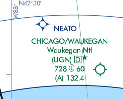
Identifier UGN, part-time Class D (star), 728 ft airport elevation, pilot-controlled lighting (circled L), longest runway is 6,000 ft, ATIS 132.4
What does "MON" mean for KDPA? Why does it matter to you?
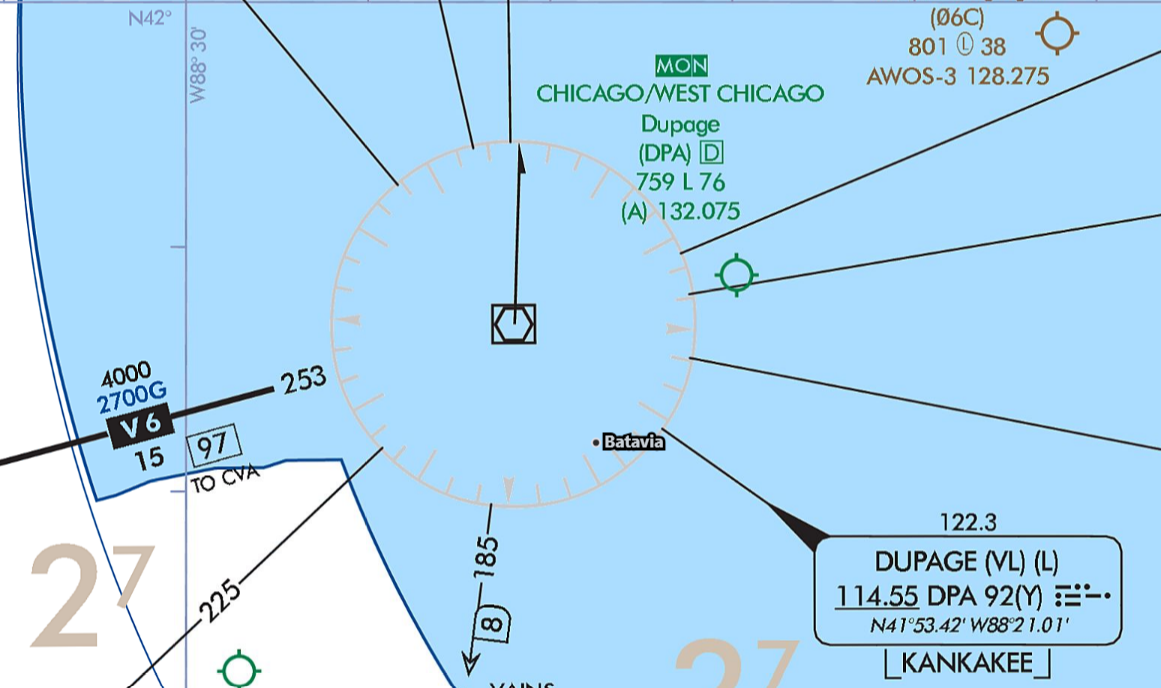
- It's part of the Minimum Operational Network (MON), which indicates it has a ground-based IAP (e.g., ILS, LOC, or VOR) that does not require DME or GPS in the case of a GPS outage (e.g., all fixes can be identified using cross-radials).
- Useful in the case of a GPS outage or an issue with your GPS
What is the purpose of the "Chicago Maple Park 134.825 307.275" box on an enroute chart?
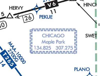
It is a Remote Center Air/Ground facility, located in Maple Park. This is the frequency to use if you need to re-establish ATC contact, but do not have a specific frequency to use.
Sources
Minimum IFR Altitudes and Cruising Altitudes
If there's no published minimum altitude for where you're flying, how low can you legally go IFR?
- Mountainous areas - 2,000 ft above the highest obstacle within 4 NM of course.
- Non-mountainous areas - 1,000 ft above the highest obstacle within 4 NM of course.
- If a minimum altitude is prescribed for the segment you're flying (MEA, MOCA, an ATC-assigned altitude, etc.), that governs instead.
- You can go below these when necessary for takeoff or landing.
Designated mountainous areas are defined by coordinates in 14 CFR part 95, and are the shaded areas on the enroute chart.
What is an MVA, and why can ATC vector you below the MEA?
- Minimum Vectoring Altitude - the lowest altitude a radar controller may vector you to within a given sector.
- It provides 1,000 ft above the highest obstacle in non-mountainous areas and 2,000 ft in designated mountainous areas, and at least 300 ft above the floor of controlled airspace. Sector boundaries are at least 3 NM from the obstacle that determines the MVA.
- MVA charts are built for the controller's radar display, not for you, which is why an assignment can look lower than the MEA or MOCA you see on the enroute chart.
- An MVA guarantees obstacle clearance. It doesn't guarantee navigation signal coverage or communications, so if you lose the vector or the radar service ends, you're back to your own minimum IFR altitude. Speak up if an assignment doesn't look right to you.
Sources
Supplements
Who picks your IFR cruising altitude, and does the hemispheric rule apply?
- In controlled airspace, you fly the altitude ATC assigns. The hemispheric rule is built into how they assign it, but it isn't your call.
- In uncontrolled (Class G) airspace under IFR you pick based on magnetic course. There is no altitude floor on the rule: unlike the VFR version it applies to any level cruising flight.
- 0° to 179° - odd thousands (3,000, 5,000, 7,000)
- 180° to 359° - even thousands (2,000, 4,000, 6,000)
- VFR-on-top is the exception. You're still on an IFR clearance, but you fly VFR cruising altitudes (odd or even thousands plus 500 ft).
Sources
Supplements
MEA, MOCA, MRA, MCA, MAA, and OROCA
What are the light brown numbers on the enroute chart, and what do they mean?
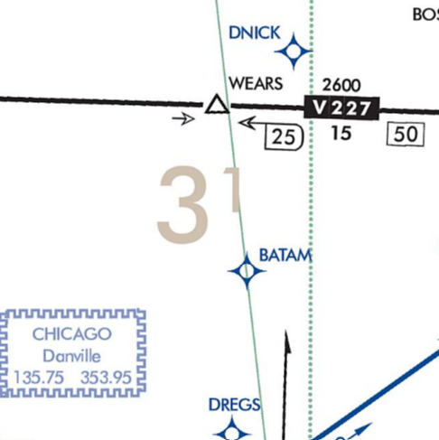
- Off-route obstruction clearance altitude (OROCA) - Guarantees 1,000 ft clearance in non-mountainous areas and 2,000 ft in mountainous areas
- You are not guaranteed any reception.
Sources
When would you use an OROCA?
When filing point-to-point and not on a published route
Sources
When might you want to request descent from MEA to MOCA?
To avoid turbulence or icing
Sources
On V24-228 off of OBK, what does "2700" mean? Why is it important?
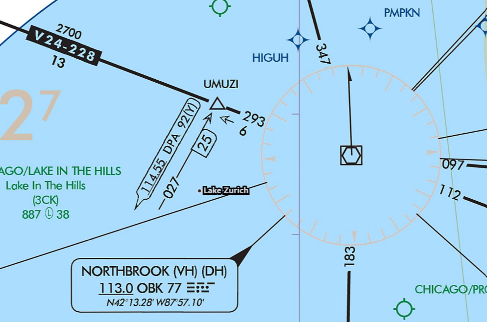
Minimum Enroute Altitude (MEA) - It guarantees obstacle clearance and navigational signal along the airway.
Sources
What does the flag with the "X" mean on LAIRD on the V7?
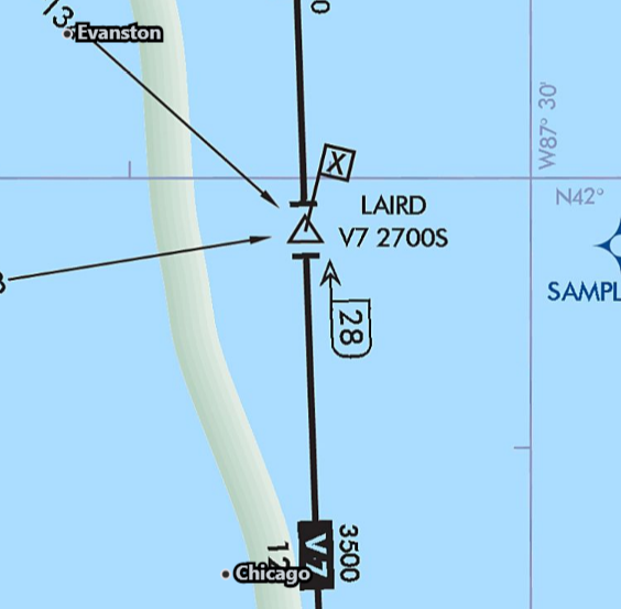
Minimum Crossing Altitude (MCA) - You must cross LAIRD at or above 2700 ft when going south on V7.
Sources
What does the "T" shape on either side of FARMM indicate?
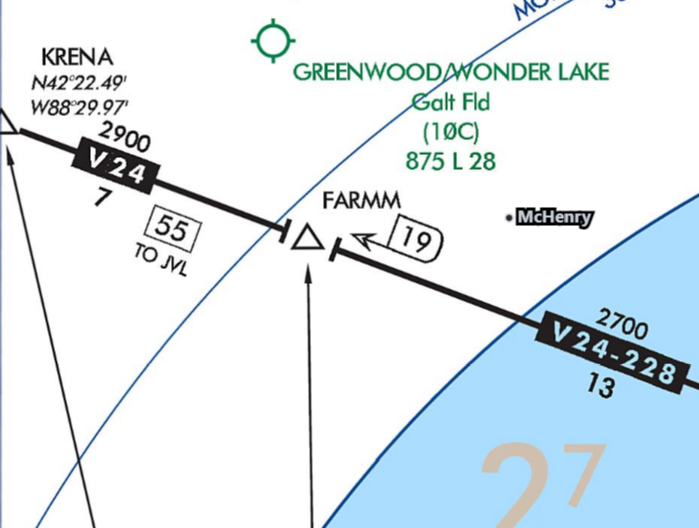
A change in the MEA occurs at that fix.
Sources
What does the flag with the "R" indicate at BOJAK on the V191 south of OBK?
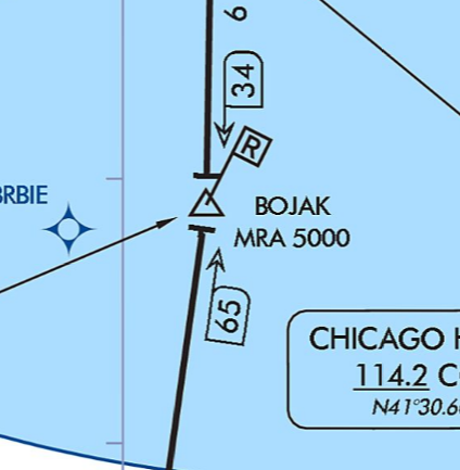
Minimum Reception Altitude (MRA) - The lowest altitude at which you can identify a fix using an off-course NAVAID (e.g., where a cross-radial is needed).
Sources
What does "MAA-10000" on an IFR enroute chart mean?
Maximum Authorized Altitude (MAA) - The max altitude that you may use this route (10,000 ft in this case).
Sources
What does "2800G" on T325 mean?
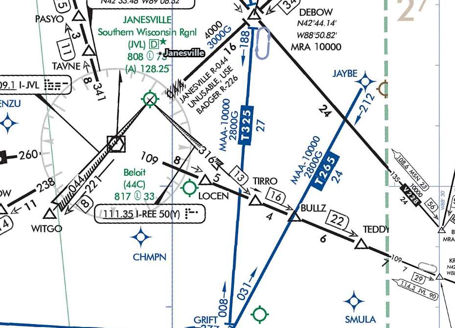
Airways, Fixes, Waypoints, and Changeover Points
What is the squiggled-out V165 airway? Can I fly it?
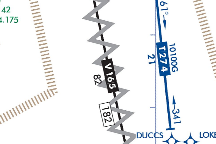
- They are unusable parts of the route, due to not enough guaranteed signal.
- You cannot file or accept a clearance that includes them, although you could fly point-to-point using RNAV.
Sources
On V24-228 off of OBK, what does the "13" mean just underneath "2700"?
The segment distance between the two fixes
What does the "19" mean next to FARMM on the V24-228 airway mean?
The total distance from the navaid (OBK) to that fix
On the V24-399 off EON VOR, what is the "X" with "(YIXCI)" next to it?
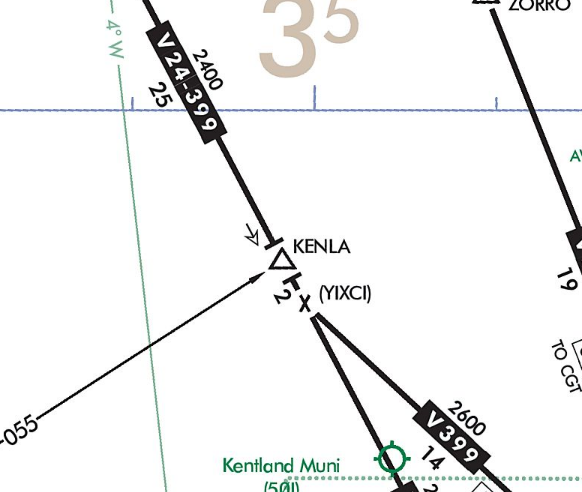
It is not a fix, just a mileage breakdown, and may indicate a course change.
Sources
On the V12 airway between BIB and SHB VORs, what does the symbol mean approximately halfway between with "61" and "70"?
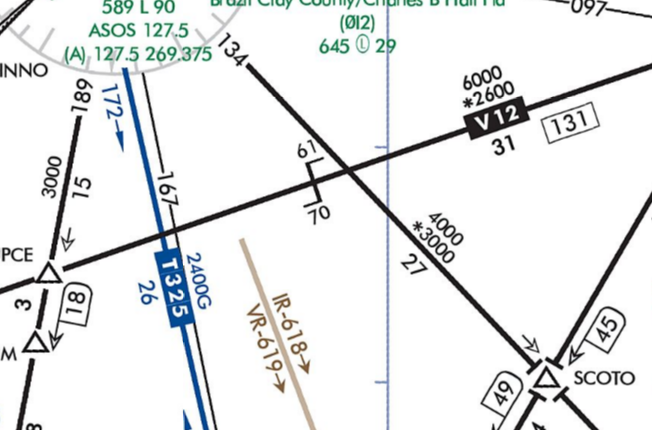
- The changeover point, which in this case says to switch from navigating V12 using BIB at 70 NM from BIB to using the SHB VOR at 61 NM from SHB.
- These appear on long airways.
The JOT VOR shows "(VH) (H)" on the enroute chart. What does that mean?
Its VOR service volume is a high MON service volume, and its DME is a legacy high service volume.
Sources
What is T325 just east of KJVL?
A Tango airway - an RNAV airway made up of GPS fixes
Sources
What's the difference between a waypoint inscribed in a circle vs one that is not?
- Circled waypoint - Flyover waypoint, i.e., one you must fly over before starting your turn.
- Uncircled waypoint - Fly-by waypoint, i.e., one where you can start the turn before overflying it (more common).
Sources
GPS / RNAV / RNP
How does GPS work?
- A constellation of satellites in medium Earth orbit, with enough satellites visible for the receiver to calculate position
- Each satellite sends a signal containing its position and the highly accurate time the signal was sent.
- Your GPS receiver uses those signals to calculate distance from each satellite, producing a sphere of possible positions.
- Additional satellite signals narrow the position solution and help correct receiver clock error.
Sources
- FAA AIM Section 1-2 - Performance-Based Navigation (PBN) and Area Navigation (RNAV)
- FAA AIM ¶ 1-2-3 - Use of Suitable Area Navigation (RNAV) Systems on Conventional Procedures and Routes
- FAA AC 90-108 Chg. 1 - Use of Suitable RNAV Systems on Conventional Routes and Procedures
- FAA AIM ¶ 1-2-2 - Required Navigation Performance (RNP)
- FAA Instrument Procedures Handbook, Chapter 5 - Global Positioning System
What is RAIM?
- Receiver Autonomous Integrity Monitoring - Onboard monitoring of the integrity of your signal, and allows for performance-based navigation (PBN)
- Requires minimum of 5 satellites or 4 with a barometric altimeter unit
- Accuracy is roughly 10-15 m.
Sources
Supplements
How does RAIM differ from WAAS?
- Wide Area Augmentation System (WAAS) - Uses ground-based reference stations and satellite corrections to improve GPS accuracy and integrity
- Accuracy is typically less than 3 m.
Sources
Supplements
What types of approaches does RAIM permit?
Non-precision GPS approaches (LNAV only)
Sources
Supplements
What types of approaches does WAAS permit?
Precision-like GPS approaches (LPV, LNAV/VNAV) and non-precision GPS approaches (LP+V)
Sources
If your GPS lost WAAS during an LPV approach but still had RAIM, what would happen?
It may downgrade to a non-precision LNAV approach, and, if so, you'd need to change your minimums. Otherwise, execute the missed.
Sources
- FAA AIM Section 1-2 - Performance-Based Navigation (PBN) and Area Navigation (RNAV)
- FAA AIM ¶ 1-2-3 - Use of Suitable Area Navigation (RNAV) Systems on Conventional Procedures and Routes
- FAA AC 90-108 Chg. 1 - Use of Suitable RNAV Systems on Conventional Routes and Procedures
- FAA AIM ¶ 1-2-2 - Required Navigation Performance (RNP)
- FAA Instrument Procedures Handbook, Chapter 5 - Global Positioning System
Supplements
What is RNP?
Required Navigational Performance (RNP) - A type of performance-based navigation (PBN) that allows aircraft to fly a specified route.
Sources
- FAA AIM Section 1-2 - Performance-Based Navigation (PBN) and Area Navigation (RNAV)
- FAA AIM ¶ 1-2-3 - Use of Suitable Area Navigation (RNAV) Systems on Conventional Procedures and Routes
- FAA AC 90-108 Chg. 1 - Use of Suitable RNAV Systems on Conventional Routes and Procedures
- FAA AIM ¶ 1-2-2 - Required Navigation Performance (RNP)
- FAA Instrument Procedures Handbook, Chapter 5 - Global Positioning System
What does "RNP-0.3" mean in an IAP plate?
Your navigation must be accurate to within 0.3 NM.
Sources
- FAA AIM Section 1-2 - Performance-Based Navigation (PBN) and Area Navigation (RNAV)
- FAA AIM ¶ 1-2-3 - Use of Suitable Area Navigation (RNAV) Systems on Conventional Procedures and Routes
- FAA AC 90-108 Chg. 1 - Use of Suitable RNAV Systems on Conventional Routes and Procedures
- FAA AIM ¶ 1-2-2 - Required Navigation Performance (RNP)
- FAA Instrument Procedures Handbook, Chapter 5 - Global Positioning System
VOR Navigation
How does a VOR work?
A reference phase signal broadcasts in all directions, and a variable phase signal rotates 360°. Your VOR receiver compares the timing differences and determines a bearing.
How far out is a VOR signal reliable?
Legacy:
- Terminal (T):
- 1,000-12,000 ft - 25 NM
- Low (L):
- 1,000-18,000 ft - 40 NM
- High (H):
- 1,000-14,500 ft - 40 NM
- 14,500-18,000 ft - 100 NM
- 18,000-45,000 ft - 130 NM
- 45,000-60,000 ft - 100 NM
Minimum Operational Network (MON):
- Low (VL):
- 1,000-5,000 ft - 40 NM
- 5,000-18,000 ft - 70 NM
- High (VH):
- 1,000-5,000 ft - 40 NM
- 5,000-14,500 ft - 70 NM
- 14,500-18,000 ft - 100 NM
- 18,000-45,000 ft - 130 NM
- 45,000-60,000 ft - 100 NM
- Terminal (T):
If you are picking up a reliable VOR signal further than the published service volume, can you use it for navigation?
Yes, but you cannot plan your flight to count on it if using the VOR for navigation. Also, be very wary of loss of signal.
Can you use GPS in place of a VOR for enroute navigation?
Yes
Sources
- 14 CFR § 91.171 - VOR equipment check for IFR operations
- FAA AIM ¶ 1-1-3 - VHF Omni-directional Range (VOR)
- FAA AC 90-108 Chg. 1 - Use of Suitable RNAV Systems on Conventional Routes and Procedures
- FAA AIM Section 1-2 - Performance-Based Navigation (PBN) and Area Navigation (RNAV)
- FAA AIM ¶ 1-2-3 - Use of Suitable Area Navigation (RNAV) Systems on Conventional Procedures and Routes
Can you use GPS in place of a VOR for an IAP?
Yes, although the VOR must be operational and monitored during the final approach segment (AIM 1-2-3).
Sources
- 14 CFR § 91.171 - VOR equipment check for IFR operations
- FAA AIM ¶ 1-1-3 - VHF Omni-directional Range (VOR)
- FAA AC 90-108 Chg. 1 - Use of Suitable RNAV Systems on Conventional Routes and Procedures
- FAA AIM Section 1-2 - Performance-Based Navigation (PBN) and Area Navigation (RNAV)
- FAA AIM ¶ 1-2-3 - Use of Suitable Area Navigation (RNAV) Systems on Conventional Procedures and Routes
DME
What can you use in place of DME?
GPS
Sources
Mandatory IFR Reports
What are the mandatory reporting points when flying IFR? When not in radar contact?
All times:
- Missed approach
- Airspeed changes of 10 kt or 5% of filed TAS (whichever is greater)
- Reaching a holding fix
- VFR-on-top altitude changes
- Leaving a holding fix
- Unforecasted weather conditions
- Safety of flight issues
- Vacating a previously assigned altitude
- Radio or navigation equipment failure
- 500 fpm climb/descent not possible
When not in radar contact:
- ETA error of 3 minutes or more
- Outer marker inbound
- Final approach fix inbound
- Compulsory reporting points
Sources
How do you identify compulsory vs non-compulsory reporting points?
Compulsory are filled in black triangles, non-compulsory are not filled in.
Sources
Do you need to report reaching compulsory reporting points when in radar contact?
No, only when not in radar contact.
Sources
Holds
Holding Entries and Timing
What are the three holding entries, and how do you pick the right one?
Draw an extended line from your current position through the holding fix to determine the right holding entry:
- Direct - When the extended line essentially takes you directly into the hold. Cross the fix and turn to follow the holding pattern.
- Parallel - When the extended line takes you outside the holding pattern, and you are not in a position to directly enter the hold. Cross the fix, turn to parallel the holding course outbound on the non-holding side for one minute (for timed legs), then turn 210° towards the protected area to intercept the inbound course.
- Teardrop - When the extended line takes you inside the holding pattern, and you are not in a position to directly enter the hold. Cross the fix, turn outbound to a heading 30° offset into the pattern, fly it for one minute (for timed legs), then turn in the direction of the hold to intercept the inbound course.
Protected airspace is designed around pilots flying these three entries at or below the maximum holding speed. Another entry isn't illegal, but combining an unusual entry with excess airspeed can put you outside protected airspace.
Sources
Supplements
When do you start timing in a hold, and how long should your legs be?
- Start timing the outbound leg when abeam the fix. If you can't determine the abeam position, start timing when the turn outbound is complete.
- Target inbound leg time:
- At or below 14,000 ft MSL - 1 minute
- Above 14,000 ft MSL - 1.5 minutes
- Fly the first outbound leg for that same time, then adjust later outbound legs for wind so that the inbound leg comes out at the target time.
- For example, if your inbound leg was only 50 seconds, then you must extend your outbound leg by another 10 seconds to bring your inbound leg to 1 minute.
- DME and GPS holds are flown to a distance instead of a time. Fly the outbound leg to the charted along-track distance from the fix.
Sources
Supplements
What do you do every time you cross the holding fix?
The 5 Ts:
- Turn - Start the turn to the outbound heading, or the turn called for by your entry.
- Time - Start the clock (if using timed legs). Outbound timing begins over or abeam the fix, whichever is later, and inbound timing begins when you're established on the inbound course.
- Twist - Set the inbound course on the OBS or HSI so your CDI shows what you expect.
- Throttle - Set holding power and airspeed.
- Talk - Report entering the hold, and report leaving it.
Sources
Holding Speeds
What are the standard max holding speeds?
- Surface to 6,000 ft MSL - 200 kt
- 6,001-14,000 ft MSL - 230 kt
- 14,001 ft MSL and above - 265 kt
Sources
When do you need to slow down for a hold?
- Begin slowing within 3 minutes of the holding fix so that you cross it at or below the maximum holding speed.
- The standard maximums are:
- Up to 6,000 ft MSL - 200 kt
- 6,001 to 14,000 ft MSL - 230 kt
- 14,001 ft MSL and above - 265 kt
- A speed in parentheses inside the charted holding pattern, e.g., (175), replaces the standard maximum. A pattern restricted to 210 kt between 6,001 and 14,000 ft is shown with an icon instead.
- If you can't comply with a published speed restriction, tell ATC.
Sources
Published vs Unpublished Holds
What information does ATC have to give you for an unpublished hold?
The holding fix, direction of holding from the fix (e.g., "West of ABC"), radial/course/bearing/airway on which to hold, direction of turns if non-standard, leg length if non-standard, and the EFC
Sources
Holding Side vs Non-Holding Side
What is the holding and non-holding side of a hold?
The holding side is where the actual racetrack pattern is flown, and provides more of a protected area than the non-holding side (which still has some protection).
Sources
Arrivals and Approach Procedures
General Approach Concepts
How are instrument approaches classified?
- Precision - Lateral and vertical guidance meeting precision approach standards, flown to a DA: ILS, PAR, GLS.
- APV (approach with vertical guidance) - Vertical guidance that doesn't meet precision standards, also flown to a DA: LPV, LNAV/VNAV, and LDA with glidepath.
- Non-precision - Lateral guidance only, flown to an MDA: LOC, LOC BC, LDA, SDF, VOR, NDB, LP, LNAV, and ASR.
Sources
Supplements
What is an SDF approach, and how does it differ from a localizer or an LDA?
- Simplified Directional Facility. It transmits on localizer frequencies (108.10 to 111.95 MHz) and you fly it much like a localizer, but with less precision.
- The course is typically 6° or 12° wide, instead of a localizer's 3° to 6° width tailored to the runway, so full scale deflection covers a lot more ground.
- The course may or may not be aligned with the runway. A localizer is always aligned with the runway, and an LDA specifically is not.
- There's no glideslope, so it's a non-precision approach flown to an MDA.
- Usable off-course indications are limited to 35° either side of the course centerline. Disregard anything outside of that.
Sources
Supplements
What's the difference between a straight-in approach and a straight-in landing?
Straight-in approach is one without a course reversal (e.g., procedure turn), and a straight-in landing is one in which you land on the designated runway for the IAP (i.e., not a circling approach).
Sources
If you're cleared for a straight-in approach, do you have to make a straight-in landing?
You're struggling to get an approach programmed in time. What do you do next?
Request delay vectors; accepting a hold may increase workload.
Course Reversals
What is a procedure turn, and what rules apply while you're flying one?
A procedure turn is the maneuver used to reverse direction and get established inbound on the intermediate or final approach course. It also gives you room to lose altitude before the final approach segment.
Rules to fly it by:
- Stay within the charted "remain within __ NM" distance, measured from the procedure turn fix.
- The charted procedure turn altitude is a minimum until you're established on the inbound course.
- Keep the speed at or below 200 KIAS from the time you first cross the course reversal IAF through completion of the maneuver. That's what the obstacle clearance area is sized for.
- On a barbed arrow, only the side of the outbound course is mandatory. The shape is up to you: 45°/180°, racetrack, teardrop, or 80°/260°, as long as you stay within the charted distance.
- If it's charted as a hold in lieu of a procedure turn, the shape is mandatory. Fly the depicted turn direction and don't exceed the charted leg length or timing.
Sources
Supplements
When do you skip a published course reversal?
A charted procedure turn or hold in lieu of a procedure turn is required when depicted, unless one of these applies:
- "NoPT" is charted on the initial segment you're using, including a straight-in TAA sector or a NoPT feeder route or arc
- ATC clears you for a straight-in approach
- You're being radar vectored to the final approach course
- You're flying a timed approach from a holding fix
- You're arriving on a DME arc that terminates on the final approach course
Two other things:
- You can still fly the course reversal when it isn't required, but you need an amended clearance from ATC first.
- If the clearance leaves you unsure whether ATC expects a course reversal or a straight-in, ask. § 91.123 doesn't leave room for guessing.
Sources
Supplements
Approach Clearances
You're cleared for the approach. When can you start down?
- Only once you're established on a published segment or route of the approach, whether that's a feeder route, an initial segment from an IAF, or the final approach course. Then you may descend to that segment's published minimum altitude.
- If you're being radar vectored, maintain your last assigned altitude until you're established on a published segment, unless ATC clears you lower, e.g., "descend and maintain 3,000 until established on the localizer."
- Published feeder routes from the enroute structure to the IAF are part of the approach clearance, so you fly them without asking for anything additional.
- If your position and the clearance don't obviously fit together, ask before you descend.
Sources
What is a contact approach, and what do you need to get one?
A contact approach is an approach you can request in lieu of flying a published instrument approach, while remaining on your IFR clearance.
To get one:
- You have to request it. ATC cannot offer it to you.
- Reported ground visibility at the destination must be at least 1 SM.
- You must be clear of clouds with at least 1 SM flight visibility, and be able to reasonably expect to continue to the destination in those conditions.
- The destination must have a published standard or special instrument approach procedure.
Once you accept it, you're responsible for obstruction clearance and for navigating to the airport. ATC still provides separation from other IFR and special VFR traffic.
Compared to a visual approach, there's no 1,000 ft ceiling and 3 SM visibility requirement, and you don't need the airport in sight to be cleared, but there are also no published minimums protecting you.
ILS / LOC / LOC Back Course
How does an ILS work?
Consists of two components - localizer and glideslope. Both have two signals each - one at 90 Hz and another at 150 Hz. The aircraft interprets its location by measuring the amount of overlap between the two signals.
How far out is a localizer accurate?
- 10 NM within 35° of centerline
- 18 NM within 10° of centerline
Sources
If you lose your glideslope outside the FAF, can you continue your approach? What would change about it?
Yes, and you'd fly to the LOC MDA instead of the ILS DA.
Sources
Can you use GPS in lieu of the localizer for lateral guidance?
Yes, prior to the final approach segment as long as you're monitoring the raw LOC data (AC-90-108), but cannot on the final approach segment.
Sources
- FAA AIM ¶ 1-1 - Navigation aids
- FAA Instrument Flying Handbook
- FAA Instrument Procedures Handbook, Chapter 5 - Global Positioning System
- FAA AIM Section 1-2 - Performance-Based Navigation (PBN) and Area Navigation (RNAV)
- FAA AIM ¶ 1-2-3 - Use of Suitable Area Navigation (RNAV) Systems on Conventional Procedures and Routes
What is a LOC Back Course?
A localizer approach from the opposite side of a traditional ILS approach
Sources
Can you fly a LOC BC on any ILS?
Not unless they're part of a published IAP.
Sources
Can you fly a glideslope on a LOC BC?
No, although you may see a false glideslope.
Sources
What's difficult about a LOC BC?
With a conventional CDI, back-course sensing can be reverse. If you are using reverse sensing, corrections feel backward compared with a normal front-course localizer.
Sources
How would you fly a LOC BC on an HSI?
Set the front course in your HSI, and you will get normal sensing and reduce the cognitive load.
Sources
What are the ILS categories, and which one can you fly?
Category Lowest DH Lowest visibility CAT I 200 ft RVR 2,400 (1,800 with TDZ/CL lighting) CAT II 100 ft RVR 1,200 CAT IIIa Below 100 ft, or none RVR 700 CAT IIIb Below 50 ft, or none RVR 150 to 700 CAT IIIc None No limitation - As a Part 91 GA pilot, you're typically flying CAT I.
- CAT II and CAT III require specific aircraft equipment (such as autopilot or autoland, dual systems, or a HUD), an FAA authorization, and specific pilot training and checking.
- The ground facility has to be certified to the category as well, and the lower minimums depend on the associated approach and runway lighting being in service.
Sources
What is a false glideslope, and how do you avoid capturing one?
- The glideslope antenna radiates additional lobes above the true glidepath. The first one that looks usable shows up at roughly twice the true angle, around 6° on a 3° glideslope, and sensing can be reversed on some of them.
- The defense is procedural: intercept the glideslope from below at the published glideslope intercept altitude, and never chase the needle down from above.
- Cross-check the charted crossing altitude at the FAF or marker. An intercept that begins unusually high, or a descent rate roughly double what you expected, is the giveaway.
Supplements
Landing from an Instrument Approach
Approach Below Published Minimums
Can you fly an approach if the weather is below published minimums?
Under Part 91, yes, although it's probably not a great idea.
Sources
Requirements to Descend Below DA/MDA
Can you descend below the DA without having any of the runway environment in sight?
- No. You may not continue below DA/MDA unless the § 91.175 requirements are met: required flight visibility, the required runway environment distinctly visible and identifiable, and the aircraft continuously in a position to descend and land using normal maneuvers.
- A momentary dip below DA while arresting the descent and initiating the missed can happen, but that is not permission to continue the approach below DA without the required visual references.
Sources
Required Flight Visibility and Reported Visibility
Per ATIS, visibility is 1/4 SM, but the instrument approach requires 1/2 SM. Under what circumstances could you land out of the instrument approach?
- The visibility minimums are flight visibility, meaning it's up to the pilot to make that determination.
- If you believe visibility is at least 1/2 SM, you may land.
Sources
- 14 CFR § 91.175(c) - Operation below DA/DH or MDA
- FAA AIM ¶ 5-4 - Arrival procedures
- FAA Instrument Procedures Handbook, Chapter 4 - Approaches
- FAA AIM Section 1-2 - Performance-Based Navigation (PBN) and Area Navigation (RNAV)
- FAA AIM ¶ 1-2-3 - Use of Suitable Area Navigation (RNAV) Systems on Conventional Procedures and Routes
Runway Environment / Visual References
What lighting allows you to continue down to the runway?
- Red terminating bar or red side row bars on ALSF-1 and ALSF-2 systems
- Runway threshold
- Threshold lights
- Runway end identifier lights (REILs)
- PAPI or VASI
- Runway lights
- Touchdown zone markings or lights
Sources
Why should we always brief TDZE?
- We can descend to 100 ft above TDZE when certain lighting is in sight.
- Helpful to know the runway touchdown elevation for the 100 ft rule and for situational awareness
Sources
Supplements
What lighting allows you to continue descending to 100 ft above TDZE?
What does a dot above an approach lighting system symbol, e.g., (A5), mean?
The approach lighting system has sequenced flashing lights, commonly referred to as a "rabbit".
Supplements
Stable Descent to Landing
Let's say you break out and have clear visibility of the runway. Can you always continue your descent?
No, you must execute the missed approach if you cannot make a stable descent while maintaining the required visual references.
Sources
What is a VDP, and what do you do if one isn't published or you can't identify it?
- Visual Descent Point - a defined point on the final approach course of a straight-in non-precision approach from which you can make a normal descent from the MDA to the touchdown point, provided you have the required visual references.
- It's charted as a "V" on the profile view.
- Descend below the MDA only when you have the required flight visibility and visual references per § 91.175(c) and are in a position to make a normal descent to the runway; the VDP is a planning aid, not a hard gate.
- If you can't identify it, for example no DME or GPS distance to the fix, fly the approach as though no VDP were published.
- If one isn't published, you can estimate it:
- Distance: HAT ÷ 300 = NM from the threshold
- Time: HAT ÷ 10 = seconds to subtract from the published FAF to MAP time
Sources
Supplements
Circling Approaches
How far out does the protected area for an airplane extend during a circling approach?
It depends on both the VS0 of the airplane and the MDA, but for most general aviation airplanes and approaches, it's 1.3 NM:
Circling MDA in feet MSL Category A Category B Category C Category D Category E 1,000 or less 1.3 1.7 2.7 3.6 4.5 1,001 to 3,000 1.3 1.8 2.8 3.7 4.6 3,001 to 5,000 1.3 1.8 2.9 3.8 4.8 5,001 to 7,000 1.3 1.9 3.0 4.0 5.0 7,001 to 9,000 1.4 2.0 3.2 4.2 5.3 9,001 and above 1.4 2.1 3.3 4.4 5.5 You're on a circling approach on an IFR flight plan at a non-towered airport. You circle to enter a left downwind for your landing runway, then turn left base, but on your turn to final, you lose sight of the runway. What do you do next?
- Contact ATC as soon as possible to obtain an amended clearance.
- If unable, attempt to re-intercept a published segment of the missed approach and comply with the route and altitude instructions.
- If unable and, in your judgment, you can no longer fly the published missed approach, consider maintaining visual conditions and reattempt a landing.
- If unable, commence a circle-climb over the airport until you are able to establish contact with ATC.
Missed Approaches
When must you go missed?
- You reach the DA or MAP without the flight visibility and visual references required by § 91.175(c) to continue.
- You lose the required visual references after descending below DA or MDA, other than during a normal descent to land once you're in a position to make a normal landing.
- You're circling and lose sight of the airport. Turn toward the runway and climb into the published missed approach.
- ATC instructs you to.
- Anything makes a safe approach unlikely: you're unstable or high, you have a navigation or instrument failure, or there's a traffic or wake conflict.
Obstacle protection assumes you start the missed approach at the DA or MAP, and no lower than the MDA, and that you climb at least 200 ft/NM unless the plate specifies a higher gradient.
Sources
Supplements
Approach, SID, and STAR Briefing Scenarios
KRFD RNAV 7
What is an MSA, and when would you use it?
- Minimum Safe/Sector Altitude (MSA) - Provides at least 1,000 ft of obstacle clearance within the specified sector/radius, usually 25 NM from the named fix or facility. It is primarily for emergency use to ensure terrain avoidance.
- It doesn't guarantee navigational signal, though.
Sources
What are the A, B, C, and D categories?
- Used to categorize aircraft by 1.3 x VS0 (IAS) to determine required maneuvering airspace and approach minimums
- A: < 91 kt
- B: 91 to < 121 kt
- C: 121 to < 141 kt
- D: 141 to < 166 kt
Sources
- Used to categorize aircraft by 1.3 x VS0 (IAS) to determine required maneuvering airspace and approach minimums
KBUU RNAV 11
You see "LP+V" on your GPS. What does that mean?
- Localizer precision, but vertical guidance is advisory only.
- Lateral navigation will get more sensitive as you get closer to the airport like an ILS localizer.
Sources
KMSN ILS/LOC RWY 18
What do the following symbols mean in the KMSN ILS/LOC 18 airport diagram section, and why are they relevant to us:
- Three ovals across 36
- (A) next to runway 36
- Arrows pointing in opposite directions on runway 36
- Star symbol on right side of the field
- (P) next to runway 36
- Black (L) next to "HIRL all Rwys"
- White dots along runway 36
- Three ovals across 36
- Displaced threshold - Useful for knowing where landable runway begins
- (A) next to runway 36
- High-intensity Approach Lighting System (ALSF-2) - Helpful to know what type of lighting we'll first see
- Arrows pointing in opposite directions on runway 36
- Bi-directional arrestor cables - Informational for civilians
- Star symbol on right side of the field
- Airport beacon - Useful to help find the airport in low visibility
- (P) next to runway 36
- PAPI - Useful to know where the indicator is that transitions us from instrument to visual flight
- Black (L) next to "HIRL all Rwys"
- Pilot-controlled lighting for high-intensity runway lighting
- White dots along runway 36
- Runway centerline lights - Useful to laterally orient ourselves when transitioning to visual flight
Sources
On the KMSN ILS/LOC 18, when would you fly the alternate missed approach?
On the KMSN ILS/LOC 18, why do they have an alternate missed approach fix?
To handle additional traffic that the airport has
Sources
KPRC RNAV GPS Y 03R
KASE LOC/DME-E
On the KASE LOC/DME-E, what does the "-E" mean?
Circling approach
Sources
On the KASE LOC/DME-E, why is it not a straight-in approach if the final approach course is aligned with the runway?
The 6.59° descent angle exceeds the 400 ft/NM straight-in descent-gradient limit.
Sources
What is the snowflake icon with -21°C next to it?
Indicates a cold temperature airport (CTA), which indicates an airport where extreme cold can create a wide enough discrepancy between true and indicated altitude that you are not guaranteed obstacle clearance.
Sources
Why might you care about the note "VGSI and descent angles not coincident" in the profile view of an instrument approach plate?
The vertical navigation path of your IAP does not match the PAPI/VASI path, and should not alarm you when your instruments indicate on-glideslope but the PAPI/VASI does not.
Sources
KRFD BIXBY ONE SID
What is the primary purpose of a standard instrument departure procedure (SID)?
- Safely and efficiently transitions aircraft from the runway to enroute while reducing radio communications
- Organizes traffic flow
- Ensures obstacle clearance
Sources
Brief the KRFD BIXBY1.QUIZZ SID for takeoff from runway 7.
- Verify the chart is correct and up-to-date.
- RNAV 1 (DME/DME/IRU or GPS) and radar are required.
- (Brief the frequencies).
- Top altitude is 3,000 ft.
- Takeoff minimums for runway 7 are 300-⅛ or standard with minimum climb of 230 ft/NM to 1,000 ft, or standard minimums and a standard climb gradient if taking off 1,700 ft prior the departure end of the runway.
- From runway 7, climb on heading 068° or as assigned and expect vectors to BODEE.
- Cross BODEE at 3,000 ft unless given a higher altitude and expect our filed altitude 10 minutes after departure.
- From BODEE, fly 207° to BIXBY.
- From BIXBY, fly the 235° course to QUIZZ.
Sources
What is a "top altitude"?
The maximum altitude authorized by the SID clearance until ATC assigns otherwise
Sources
On the KRFD BIXBY ONE SID, what does "3,000" mean between BIXBY and QUIZZ, and when would you abide by it?
- It's the MEA, used for obstacle clearance and lost comms planning on that segment.
- Otherwise, abide by crossing restrictions up to your top altitude.
Sources
If you're on the SID and are told by ATC "Climb and maintain 4,000", what does that mean?
You must still fly the lateral path and comply with any speed restrictions, but published altitude restrictions are canceled and you climb to 4,000 ft.
Sources
If you're told "Climb via the SID" on the KRFD BIXBY ONE SID, what does that mean?
You must fly the lateral and vertical path, and comply with any speed restrictions.
Sources
KRFD ALEXS ONE STAR
What is the primary purpose of a standard terminal arrival route (STAR)?
- Safely and efficiently transitions aircraft from enroute to terminal procedures while reducing radio communications
- Merges traffic flows, altitudes, and speeds
Sources
Brief the KRFD MILAA.ALEXS1 arrival.
- Verify the chart is correct and up-to-date.
- RNAV 1 (DME/DME/IRU or GPS) and radar are required.
- Cross MILAA at FL240 and track it on the 097° course to FRRNK 39 NM away.
- FRNNK has a crossing restriction of 13,000 ft and 250 kt, requiring a 3° descent starting at least 33 NM from FRRNK.
- At FRRNK, turn to course 098° to ALEXS and cross FRDEE at 7,000 ft, which requires starting a 3° descent immediately from FRRNK.
- Expect radar vectors to the final approach course.
Sources
Talk me through your descent planning from MILAA to FRRNK on the KRFD MILAA STAR with a groundspeed of 240 kt.
- We have 11,000 ft to lose (FL240 - 13,000), so we want to start a 3° descent at least 33 NM from FRRNK.
- The distance is only 39 NM, so we should start the descent right away to give ourselves a buffer.
- Descent rate should be 1,200 fpm.
Sources
How do we get from ALEXS to KRFD on the KRFD ALEX ONE STAR?
098° track to FRDEE, then radar vectors to the final approach course
Sources
On the KRFD ALEXS ONE STAR, what is the crosshair symbol on the plan view?
It represents the airport.
Sources
Airport Operations
Closing IFR Flight Plans
You land at KPWK at 0600Z after an IFR flight. What do you do after you land?
Close my IFR flight plan through 1-800-WX-BRIEF or ForeFlight.
Do I need to close my IFR flight plan if I land at 2300Z?
No, the tower is still open, and towered airports will automatically close your IFR flight plan upon arrival.
Sources
You're flying into a non-towered airport on an IFR flight plan, and it's VMC. What should you consider doing prior to arrival?
Cancel IFR so that ATC does not need to lock down the airspace for other IFR traffic.
Airport Lighting
What are the runway lights and what do their colors tell you?
Light Color Edge lights White. On an instrument runway, yellow replaces white over the last 2,000 ft or half the runway length, whichever is less, forming a caution zone for landings End lights Green outward from the runway end, marking the threshold to a landing aircraft, and red toward the runway, marking the end to a departing one. The same fixtures, read from opposite sides Centerline lights (RCLS) White until the last 3,000 ft, then alternating red and white for 2,000 ft, then all red for the last 1,000 ft Touchdown zone lights (TDZL) Steady white bars either side of the centerline, starting 100 ft beyond the threshold REILs A pair of synchronized flashing lights at the approach end, for rapid identification of a runway surrounded by other lighting Sources
Supplements
How do you identify a taxiway at night, and what do the lead-off lights mean?
- Edge lights are blue. That is the identifier: blue means taxiway.
- Centerline lights, where fitted, are steady green.
- Lead-off lights are alternating green and yellow, beginning with green at the runway centerline. They guide you off the runway and the color coding is a warning that you are still within the runway environment or the ILS critical area, whichever is more restrictive. You are not clear until the alternating pattern ends.
- Lead-on lights entering a runway use the same alternating pattern, for the same reason.
- Clearance bars at a holding position are three in-pavement steady yellow lights.
Sources
Supplements
How do you know if an airport has pilot-controlled lighting? How do you use it? When should you use it?
Pilot-controlled lighting is indicated with an "(L)" symbol on VFR sectional and IFR enroute charts. To use it, tune to the CTAF/UNICOM frequency and key the mic 3 times for low-intensity lighting, 5 times for medium-intensity lighting, and 7 times for high-intensity lighting. The lighting will remain on for 15 minutes. You should use it when it's dark out prior to approach to landing. While on an instrument approach, you should turn it on during your final approach segment so you can see the runway at nighttime after breaking out of IMC.
Supplements
ILS Critical Areas
What is an ILS critical area?
A protected area near the runway localizer and glideslope antennas that keeps aircraft and vehicles from disturbing ILS signals for inbound aircraft.
Sources
How do you identify an ILS critical area?
- Yellow painted ladder-style markings
- Red sign with white letters "ILS"
Sources
How do you know when an ILS critical area is active?
- Towered airport - ATIS or ATC will inform you.
- Non-towered airport - If ILS is being used and there is an inbound aircraft, hold short of it.
Sources
Instrument Systems and Failures
Pitot-Static System
How does a traditional altimeter work?
Static air pressure compresses aneroid wafers while natural springiness tries to expand them. As pressure decreases, the aneroid expands and indicates a higher altitude, and vice versa.
Sources
Altimeter and Temperature / Pressure Errors
Altimeter setting is 30.42, and you reach FL180 and re-adjust your altimeter setting. What does your altimeter show now?
You'll reset to 29.92 at FL180, which will show 17,500 ft (you moved the datum 0.50 inHg lower, which corresponds to about a 500 ft drop).
Sources
Using ATIS-supplied altimeter setting, your altimeter is showing an airport elevation of 83 ft lower than what's published. Can you fly IFR?
No, it exceeds the 75 ft tolerance.
Sources
You fly from 30°C to 0°C while maintaining the same indicated altitude. What happens to your true altitude, and why?
- True altitude decreases. Your altimeter assumes standard pressure-level spacing, but in cold air those levels compress and occur at lower true altitudes.
- Remember - "High to low, warm to cold - look out below!"
Sources
What happens to your true altitude if you fly from a low pressure to a high pressure system without changing your altimeter?
True altitude increases. As outside pressure increases, the altimeter interprets the higher pressure as being lower, so you climb to maintain the same indicated altitude.
Sources
Static Port Blockage
If your static port becomes blocked and you descend, what happens?
- Your altimeter will continue to show the same altitude.
- Your VSI will show zero.
- Your airspeed will show a higher indicated airspeed. The pitot side senses the higher ambient pressure during descent, while the static side remains trapped at the lower pressure from altitude, so the ASI sees an artificially large pressure differential.
Sources
What steps might you take to resolve a blocked static port?
Turn on the alternate static source.
Sources
What errors does an alternate static source create?
- Cockpit static pressure is usually lower than outside static pressure.
- That lower pressure usually causes the altimeter to indicate higher.
- That lower static pressure usually causes the airspeed indicator to read higher.
Sources
Pitot Tube Blockage
Your airspeed suddenly drops unexpectedly, but your power and pitch settings remain stable. How do you troubleshoot?
Suspect a blocked pitot/ram air source. Turn pitot heat on and see if the issue resolves. Use known pitch and power settings to land safely if not.
Sources
Your airspeed indicator shows an increase during a climb and a decrease during a descent. What's happening?
You likely have a blocked ram air and drain hole, which causes the airspeed indicator to act as an altimeter.
Sources
Electrical Failure
You are in IMC and notice a low voltage indication. What might be happening, and what are next steps?
- Possible alternator failure
- Follow the checklist, reduce electrical load, and troubleshoot.
- Notify ATC and request vectors or routing to the nearest VMC or suitable airport.
- Land as soon as possible.
Sources
Supplements
Vacuum Failure
You're flying a steam gauge airplane, and start getting confused by the conflicting information your instruments are displaying. You look at your suction gauge and notice it's low. What's wrong?
You have a vacuum system failure, and are likely to lose your attitude indicator and directional gyro.
Sources
Supplements
When your vacuum system fails, which instruments should you rely on for pitch? For bank? For heading?
- Pitch - Altimeter and airspeed indicator (VSI for trends)
- Bank - Turn coordinator
- Heading - Magnetic compass
Sources
AHRS / PFD / MFD Failures
What is AHRS and how does it work?
- The system computes aircraft attitude and heading and replaces traditional six-pack instruments.
- A magnetometer senses direction, accelerometers sense acceleration, and solid-state gyros sense attitude/rotation.
Sources
Supplements
Aeromedical Factors
Spatial Disorientation and Illusions
What is spatial disorientation, what causes it, and how can you avoid it?
Spatial disorientation is an incorrect perception of the aircraft’s attitude, position, or motion relative to the Earth. It occurs when visual, vestibular (inner ear), and proprioceptive ("seat-of-the-pants") senses provide misleading or conflicting information, especially when reliable outside visual references are absent. Prevent/correct it by trusting the flight instruments rather than bodily sensations when visual references are unreliable. Maintain instrument proficiency, anticipate conditions that can cause illusions, and avoid unnecessary abrupt head movements during prolonged turns.
What vestibular illusions should you expect in IMC, and what causes each?
- The leans - The most common one. A slow roll you don't feel, corrected abruptly, leaves you feeling banked the other way while the instruments show wings level.
- Coriolis - Moving your head on a different axis during a prolonged turn stirs the fluid in the semicircular canals and produces a violent sensation of tumbling. This is why you don't drop your head to grab a chart in a turn.
- Graveyard spiral - In a prolonged coordinated turn, the sensation of turning fades. Roll out and you feel like you're turning the other way, so you turn back, notice the altitude loss, and pull, which tightens the spiral.
- Somatogravic - Rapid acceleration feels like a pitch up, which tempts you to push over. That's dangerous on a go-around or missed approach. Deceleration feels like a pitch down.
- Inversion - An abrupt level off after a climb feels like tumbling backwards.
- Elevator - An updraft feels like a climb, prompting a nose down input.
The fix for all of them is the same: believe the instruments, keep the scan moving, and keep your head still.
Sources
Supplements
Unusual Attitudes
Recovery from Unusual Attitudes
Explain how to recover from unusual attitudes, and why it differs when in a climb vs a descent.
- When in a climb, go full power while lowering the nose, the roll wings level.
- Lowering the nose may require strong nose down pressure.
- When in a descent, pull the power out while rolling wings level, then slowly pitch up.
- Rolling wings level while in a descent is necessary to unload the wing so that it does not stall at a higher airspeed during recovery.
Supplements
- When in a climb, go full power while lowering the nose, the roll wings level.
Lost Communications
Lost Comms Scenario: KPWK to KMSN
You're planning a flight from KPWK to KMSN. You're given the following clearance: "Archer 12345, you are cleared to JVL VOR via radar vectors OBK, V24 JVL. Climb and maintain 2,000, expect 3,000 10 minutes after departure. Expect further clearance at 1830Z." The time of departure is 1800Z. You depart, switch to departure, but hear nothing. What do you do?
- Check that headset plugs are secure.
- Try switching to COM 2.
- Try switching to the last known good frequency.
- If you have a backup handheld radio, use it.
- Squawk 7600.
If VMC:
- Land as soon as practicable.
If IMC:
- Climb to 2,000 ft, then 3,000 ft 10 minutes after departure.
- Use the highest of assigned, expected, or minimum IFR altitude.
- Proceed direct to OBK, then V24 to JVL.
- You have not been assigned direct OBK, but you were being vectored to it (assigned, vectored, expected, filed - AVEF).
- Hold at JVL until EFC, then proceed direct to an IAF at an IAP at KMSN.
- Hold at the IAF until your filed ETA, then commence the IAP.
- Call KMSN tower on the phone when safely on the ground.
For routing:
- Assigned
- Vectored
- Expected
- Filed
For altitude, the highest of:
- Minimum for your route segment (could be an MEA or OROCA)
- Expected
- Note: Wait until the expected time has elapsed before considering climbing to the expected altitude. For example, if told "Climb to 3,000 ft, expect 4,000 ft 10 minutes after departure", do not immediately climb to 4,000 ft if that's the highest altitude - wait until the 10 minutes have elapsed, then evaluate the highest altitude and climb to that.
- Assigned
Sources
During IFR lost comms, what do you do if you get to your clearance limit and your EFC has already elapsed?
Proceed direct to an IAF and hold until your ETA.
Sources
During IFR lost comms, what do you do if you get to the IAF and your ETA has already elapsed?
Commence the IAP immediately.
Sources
What do you do if you need to lose a lot of altitude upon reaching your IAF before shooting an approach during IFR lost comms?
Descend while holding at the IAP.
Sources